Topography and Bathymetry
Email us: consultant@seisxploregeosurvey.com or phone/WA: +62 821 7211 1561
Sub Bottom Profiler Survey in The Meulaboh Port
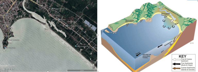
The island of Sumatra in general has a physiographic trend in the form of a series of Barisan mountain ranges on the west side of the island, this mountain range separates the west and east coasts. The slopes facing the Indian Ocean generally have steep characteristics. As a result, the coastal series on the west tend to be mountainous, except for two embayments in North Sumatra (Meulaboh and Singkil). The island's east side is occupied by extensive hills formed from tertiary formations and alluvial lowlands.


Figure 1. Comparison of the physiographic conditions of Meulaboh (taken from Google Earth imagery in 2023) with the conceptual embayment model
When correlated with the regional geological map on the Takengon sheet land (N. R. Cameron, 1983) the survey area is underlain by the Tutut Formation (QTt) which is formed by the alternation of sandstone, mudstone, conglomerate, and a thin layer of lignite. The average thickness of this formation is several hundred meters. The upper part of this formation is formed by the alternation of sandstone, light grey mudstone and thin coal inserts. Consistently above it is the Meulaboh Formation (Qpm) which consists of sandstone, clay and gravel/gravel, its position is relatively parallel to the coastline. Above the Meulaboh Formation, recent deposits are deposited, in the form of loose grains from clay to gravel size. These recent deposits are spread along the West Coast and around the main rivers.


Figure 2. SBP recording of IC BS2 tracks kilometre 0+240 – 0+640. The SBP recording shows a seabed feature in the form of a sandbar to the south.
On the IC BS2 track, it is a north-south track, this track is the track closest to the pioneer pier. There is a seabed feature in the form of a height at coordinates X: 456495 m, Y: 181561 m, this height extends to the IC BS3 track about 50 meters. This feature is a sand bar that is formed parallel to the coastline, the sand bar is a characteristic of the depositional environment where the influence of waves is more dominant than the tidal process. In areas like this, the tidal process only raises and lowers the water level. After the bar is formed, some fine material can be deposited behind the bar towards the land. The reflection pattern of the layer near the seabed shows a parallel but discontinuous reflection pattern which is interpreted as a layer of fine sandy silt.

Figure 3. SBP recording of IC BS6 tracks kilometre 0+140 – 0+640.
The IC BS6 track is parallel to the IC BS2 track with a distance of about 245 m to the east. On the IC BS6 track, no sandbar was found. In the northern part of this track, the depth is getting shallower with steep seabed conditions and has different reflection characteristics. In the northern part, it is interpreted as a rock unit in the form of sandstone that has undergone an erosion process and is part of the Meulaboh Formation, this sandstone is connected to the mainland.


Figure 4. SBP recording of 2MBS3 kilometre track 0+000 – 0+600. Thinning of the seabed dominated by sand.


Figure 5. SBP footage of the 3MBS4 kilometer track 0+000 – 0+600
